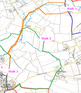
Map showing the route of the walk as described below
Route 3 from Village shop to Yarlington Mill and return (about one and a half hours)
With back to shop, take path WN19/67 to right (west) across field, through gate and over sleeper bridge.
Join with WN19/107 and straight ahead (north) through gate and alongside school playing field.
Continue on WN19/66, (which becomes WN19/65) diagonally across field (north) to far corner.
Descend short flight of stone steps onto Sandbrook Lane.
Turn right, (north east).
Follow lane round bend to left, over old stone bridge over River Cam and take path WN19/61 through gate on right.
Follow path to where it exits onto Sandbrook Lane and turn right (north).
Follow lane to Hewlett’s Mill on bend.
Take path WN19/29 over stone stile in wall to right.
After 15m turn left through wooden gate and straight ahead along River Cam, to where path divides.
Take path to left (north) through gate, over sleeper bridge, over stile and turn right (north east) onto WN19/30.
Walk to stile following River Cam.
Over stile and bridge and cross WN19/42 straight ahead onto WN19/31.
Bear right onto WN19/32 to stile and straight on to WN19/33.
Continue straight (east) to stile /gate onto Stoke Lane.
Turn right on lane and after 100 m take WN19/42 on right (east).
Straight on path to end of hedge ahead. N.B. at this point walk to the left of the hedge.
Follow path along hedge at edge of field.
Through gate turn right onto Quarter Lane (an unmetalled track).
Straight ahead (north west) to junction with WN19/30 and WN19/31.
Retracing beginning of walk, turn left onto WN19/30, then over sleeper bridge left on WN19/29, through wooden gate and right onto gravel drive.
Over stone stile in wall and left onto Sandbrook Lane, retracing route along lane to beginning of WN19/61 ) on left.
Follow WN19/61.
Emerge onto Sandbrook Lane.
Turn left.
On right bend, go up stone steps on left, and follow WN19/62 along field boundary to right, parallel with lane, over stile onto WN19/63 straight ahead, across field, over stile, then short distance along school playing field and down a flight of steps.
Turn left and follow path WN19/64 straight ahead (south) behind school.
Turn left onto WN19/107.
Where path divides, bear left onto WN19/67 over small bridge and through gate, across field and through gate.
Straight ahead (south) on track and emerge on to Woolston Road adjacent to shop (on left).
The interactive Rights of Way map, not only maps all footpaths and bridleways and restricted byways, but walkers can report where they find faults with stiles etc. and cross cropping of paths.
The Countryside Code helps give balance with regard to the relationship of public rights over private land and encourages responsible use of the routes.
Funded by Somerset Community Grant & donation from The Newt