Map showing the route of the walk as described below
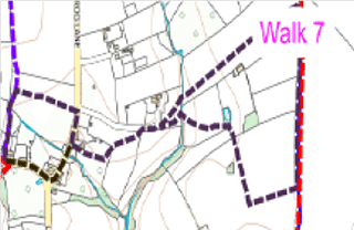
Route 7 from Village Hall start and return (about one and a half hours)
Facing north, with back to Village Hall walk slightly to right.
Cross Long Street to take path between houses WN19/13 (north), through gate, over stile, onto WN19/12 to mid-field, turn sharp right 90° (east), WN19/14, down centre of field to gate onto Frog Lane.
Turn right and shortly left on WN19/27 between cottages, through gate into orchard.
Turn left at finger post mid-field.
Over stile in corner, across next field to left corner and over stile.
Still on WN19/27, follow path to corner with drive straight ahead, then over stile.
Bear left (north east), over stile and bridge and straight ahead to distant boundary.
Over stile, onto WN19/97 (Hicks Lane).
Turn right (south) along Hicks Lane, to second gate on right.
Through gate onto WN19/100.
Walk to mid-field (large oak tree). Turn 90° right to stile.
Shortly before pond ahead bear left, over stile and straight ahead (west) to gate and bridge over stream.
Across field to stile crossed on earlier part of walk.
Retrace steps on WN19/27 to Frog Lane.
Turn left.
At triangle, bear right along Long Street to Village Hall on left.
The interactive Rights of Way map, not only maps all footpaths and bridleways and restricted byways, but walkers can report where they find faults with stiles etc. and cross cropping of paths.
The Countryside Code helps give balance with regard to the relationship of public rights over private land and encourages responsible use of the routes.
Funded by Somerset Community Grant & donation from The Newt